For this project, I study on the transportation of the site about people transport sugar cane from their fields to Cinclare over time. The timeline shows from 1880-1920, which is the time period that Cinclare developed itself. The radios of the timeline also show the area of the nearby agricultural fields, you can see when the sugar mill developed better, more farmers are willing to send their sugar cane to Cinclare. The black dots are the existing agricultural fields that still in use. Except the timeline, there's also a path line of the truck when it carried the sugar cane from fields to sugar mill across the Mississippi River. On the way, you can see the Bridge, boat and river when you drive and finally get to see the high bright chimney stack and park in the huge steel structure, and dump the sugar cane on the conveyer to transport into the mill.
Friday, February 28, 2014
Thursday, February 27, 2014
[Project 02] Parallax
Drawing + Photoshop
By drawing multiple sections of the site, it compares the landform of east and west baton rouge that are divided by Mississippi River. And you can also see the differences of the thickness of soil and river, the high point and low point of the area, the flat field ground and skyline.
I overlap all the sections together at the bottom of the drawing, so you can see the difference of west and east baton rouge more straightforward. It shows the location of Cinclare sugar mill, the differences of height elevation in order to help me understand the context,elevation differences and scale of the site.
Tuesday, February 25, 2014
Monday, February 24, 2014
[Project 03] Interval
From my last site visit, the empty feeling of the site makes me wondering how was the site looks like before, So I try to dig more about the historical human activity on this site. As I mentioned in the last posting, the large steel structure used for transport sugar cane from fields to inside of the mill. Trucks of sugar cane came to the sugar mill one after another and this large steel structure was like a semi-open space for trucks to have a short stay.
1. I use folded paper as brush dip ink to create the texture of the context of the site along Mississippi River.

2. At the centre of the drawing is my last site observation drawing, it's like the destination of all that trucks from different sugar cane fields of Cinclare sugar mill.
Sunday, February 23, 2014
[Reflection] Idea of Project3

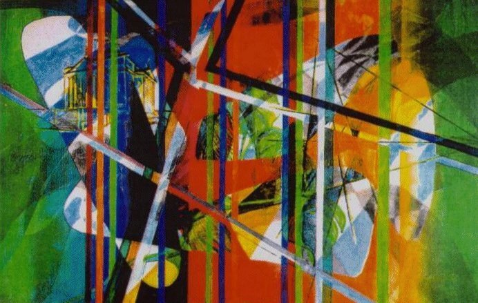
.II. VILLA ROTONDA, S.W. HayterCollection of Julian Hayter, Paris.'Hayter e l'Atelier 17', 117 x 179 cm, 1980.
Vertical and diagonal parallels on a complex of curves partly obliterated, with some figuration in the background.
For project 3 interval, i'm gonna study on the color change of the industrial complex itself over time. The main idea is "revealing"-- How the new color shows after the original surface has been eroded; which also has the change of texture between the old working sugar mill and nowadays abandoned sugar mill. The picture below is a simple attempt of this idea. I use the method from what the art work showed above: Partly obliterate the front photo of the old in-use sugar mill in order to let the new color of the material under it appear.
Subscribe to:
Posts (Atom)


